Tuesday, 1st of September 2009 at 10:34:53 PM

The Herzogstand-Heimgarten Hike 2009

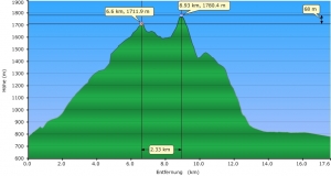
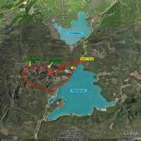
They had announced this would be the last summer day of 2009. I try to do this hike once a year so, this year after 2007 and 2008 the 3rd time.  Being owner of a Oregon 300 GPS since my last US trip, I could for the first time log my hike and create following profile out of the gpx.log.

It took me 7 1/2 hours this year. Never been so slow.  The weather was fantastic.   The view towards the north (Starnberg Lake, Ammersee) and to the Alps was amazing. The hike itself can be divided in 4 parts:

  • 6 km steep climb of 1000m altitude towards Herzogstand peak (2 h). The “exhausting” part.
  • 2 km along the rim between Herzogstand and Heimgarten (1.5 h). The “Nice” Part!
  • 1000 m in 3km descent from Heimgarten towards Walchensee. The “endless” Part!
  • 4 km along the Walchensee shore back to the car park near Urfeld. The “tired and aching” part!

Google Earth KML file    (save as .kml ->you need Google Earth installed)

GPX File

All the fotos of this hike

Related Posts:

Sunday, 27th of July 2008 at 10:50:44 AM

Herzogstand-Heimgarten 2008

In 2007 as a preparation for my 220 km hike on the Camino de Santiago I had done the Hike to the Herzogstand (1730m). I was  in good shape then and it had took me 6 hours of quick hiking for the whole roundtrip. This year I am little bit fatty and not in good shape but I wanted to recheck if I can still do that hike in 6 hours. The hike starts in Urfeld upper forest parking lot at around 850m and in 1 h 30 min of steep nonstop climbing along a forest road I reached (totally wet from sweating) the Herzogstandhaus (1575 m). Another half hour later I reached the peak of the Herzogstand (1730 m) were I had a 10 min break with a Brezel and lot of water. I already knew that I am slower this time then the year before.

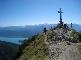
View from Herzogstand Peak (1730m) along the ridge to the Heimgarten Peak (1790m)  in the background.

The most beautiful part of the Hike is the ridge between the Peaks of the Herzogstand to the 60m higher elevated Heimgarten (1790 m). You have nice views to the Kochel Lake and the Lake Walchensee. Its always adventurous to do a ridge hike and here you have always these nice views down to the Kochel- and Walchen- Lakes, and to the Alps and you can see also very good to Lake Starnberg in the distance. Another Break at the Heimgarten where I stayed a little bit longer to enjoy the views and to relax, cause meantime I was really tired.

View back from Heimgarten to the Herzogstand peak with Lake Walchensee on the right.

Finally the easy part, another 2 hours walk down the Heimgarten from 1790m down to 850m at the small village of Walchensee directly at the same named Lake. The last part then the 4 km back to the car parking in urfeld  along the Lake  took me another 45 minutes. This year the whole trip took me 6h 30.

Down at the Walchensee Lake, view to the Jochberg (1570m).

Related Posts:

Monday, 21st of May 2007 at 08:57:39 PM

some more training for Santiago

After doing nothing for weeks today I started my final preparation for the Santiago trip to spain. A wonderful  40 km bike tour along the Bad Tölz Isar Valley and back through typical bavarian small farming villages, through cows, horses and farmers doing their field work. I got lost twice.

Related Posts:

Sunday, 29th of April 2007 at 08:14:31 PM

Aiplspitze and Jägerkamp

Today Christiane and I hiked in the Spitzingsee region. We took the lift up to Taubensteinhaus and then we hiked up via Rauhkopf (1689m) and the challenging ridge up to Aiplspitze (1759m). Back down to the valley we crossed the Jagerkamp summit (1746m) and then 2 hours walking straigth down to the car park at the lake Spitzingsee.

spitzingsee_04_2007_052.jpg

Christiane hiking along the ridge with Aiplspitz summit cross in the background

spitzingsee_04_2007_129.jpg

Christiane and Lake Spitzingsee.

Related Posts:

Friday, 27th of April 2007 at 07:21:58 PM

Hiking tour to Mt. Herzogstand and Mt. Heimgarten

Doing some training for my June Hiking trip to Santiago di Compostela. Today I hiked up to Mt. Herzogstand(1731m) and on the ridge to Mt. Heimgarten(1790m) (in total 6 hours).

herzogstand_heimgarten_04_2007_08.jpg

View from ridge walk near Herzogstand

Related Posts: