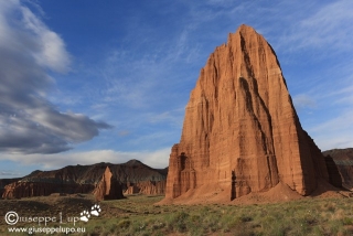
I woke up at 5 am behind the “Temple ofthe Sun”. I had slept bad, cause my legs were full of stings from the Coyote Gulch Hike in Shorts. Furthermore heavy windstorms in the night, woke me up again and again. It was still cloudy in the morning but I found a nice moment to take this foto of the Temple of the Sun (foreground) and Moon (back). I had parked my Car, for Sleeping in it. right between those two landmarks. Nobody did complain. But nobody was there.
sunrise at the Temple of the Sun (and Moon in the back)
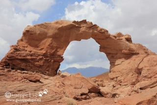
Then I drove down the Cathedral Valley back to US24 and took eastern direction to Hanksville. I had a good Omelet (Rio Bravo style) in Hanksville, and then I drove around 30 miles south to hike to the Arsenic Arch. It’s trail head is located 5 miles east of the Highway and reachable through a sandy road. Therefore I was little bit concerned when I was at Arsenic Arch and it began to rain. It was only a shower.
Arsenic Arch
When I returned from the Arsenic Arch Hike it was noon and excellent to do the transit to Moab, a 2h30 drive. During noon time photographing is not very fruitful.
Road tripping USA Southwest
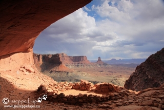
In Moab I drove to the Canyonlands (Island in the Sky) Visitor Center to pickup my permit for the next days (sunday) adventure. Then I drove to White Rim and Buck Canyon Viewpoint and finally I drove to the False Kiva Trail head for a short 3 mile round trip evening Hike. I like that spot very much, It’s not mentioned in the official Park Guides but I knew it through the brilliant book series “Photographing USA Southwest from Laurent Matres.”
False Kiva
Finally I had a look at the Shafer Trail Switchbacks where I had planned to drive down the second time after 2011.
Shafer trail Switchbacks
Hiking Mileage today: 5.6 km / 3.5 miles
Hiking Mileage total: 99.0 km / 61.9 miles
curious incidents today: it began to rain when I arrived at Arsenic Arch


